|
|
||
|
||
|
Privacy Policy | Editorial Policy | Profit Policy | Join the Association | List of Members | Contact us | Index | Links |
||
|
Back Go to page: 1 2 3 4 5 6 7 8 9 10 11 12 13 14 15 16 17 18 19 20 Forward
|
||
|
John Laming. |
||
|
|
||
|
On your own, airline flying in the South Pacific before GPS.
The island of Nauru, Latitude South 003.28.3, Longitude East 166.55.0, lies on the Equator where it circles over the Central Pacific. In 1976, when this story starts, it took just 25 minutes to ride around the island on my trusty Honda 50.
An NDB and DME were the only navigation aids on the island. Both sometimes failed without warning. Local fishermen rely on the aerodrome beacon light for navigation in case the ocean currents drift them out of sight of the low-lying atoll. At night the beacon attracts sea gulls like moths around a flame.
|
||
|
|
||
|
The F28 parked at Nauru with my Honda 50 in the foreground.
|
||
|
In those days, Nauru’s runway was 5600 feet long and, with the ocean at both ends, there were no over-run safety zones. Air Nauru crews drinking at the bar of the island’s Menen Hotel agreed it was best to keep going if an engine failed within 15 knots of V1. An Australian-designed T-VASIS lay submerged under long grass surrounding the sealed runway. It too was unreliable, susceptible to vandals breaking the lights after dark. For the weary crews arriving from all points of the compass en route to Melbourne or Hong Kong, the VASIS was indispensable.
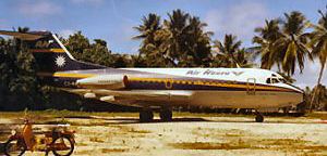
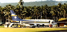
I was a passenger on an Air Nauru F28 that had just landed from Melbourne with stops at Sydney, French New Caledonia, and the Solomon Islands. Recruited by Air Nauru, I was on the island to receive a briefing on the route structure over which I would fly for the next 10 years. The airline had two F28s and two B737-200s. The latter were equipped with a gravel protect kit and low-pressure tyres for operations from coral airstrips and among the destinations served by Air Nauru were Hong Kong, Taipei, Manila, Truk, Ponape, Guam, Okinawa, the Solomon Islands, the Gilbert Islands, and Fiji.
After the comfortable air conditioning of the F28, I was struck by the
equatorial heat and sweating humidity as I walked toward the small
airport terminal. Hearing the sound of an approaching jet, I turned
around and there was my first Boeing 737 as it turned on final for
runway 12. Twin smoke trails from its Pratt & Whitney JT8D-17 engines
curled down toward the ocean breakers that surrounded the atoll and
seconds later, with a spurt of blue smoke from tortured tyres, the
Boeing smacked down hard o
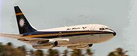
A Boeing 737-200 flashes over Nauru.
It was a well-executed short field landing and all the more impressive for the shattering roar of full reverse thrust reverberating through the wartime fibro houses among the coconut trees that surrounded the airstrip. Now that, I thought, is a real man’s aeroplane – and one day I would fly it. As I was to find out later, the F28 was a kiddy-cart when compared to the sheer brute force of the 737.
A year passed and, with new-found skills on the lovely little F28, it was time to go to New Zealand where Air Nauru had arranged for crews to undergo type rating training on the Boeing 737-100 of the National Airways Corporation. Mid-winter in Christchurch was a marked change to life in the tropics, but we were well rugged-up, as the frost sparkled on the green parks of that beautiful city. English-style pubs abounded, with their friendly atmosphere and cosy fireplaces. After daily lectures, we gathered at the bar, beers in hand, and admired the rosy-cheeked girls from nearby Christchurch University.
In late 1977 I obtained my command on the 737. There followed many happy years flying Pacific air routes, navigating with combinations of Doppler, Omega or INS. One regular route was Nauru to Faleolo airport at Apia, the capital of Western Samoa. The over-water distance to Apia, position South 13.49.9 and West 171.59.8, was 1485 nm. The short runways at Nauru and Apia meant fuel uplift was critical for such a long distance, but fortunately over that route winds were generally light giving a flight time of under four hours.
The only airport on the direct track was Funafuti atoll in the Ellis Islands, roughly halfway between Nauru and Apia. The short coral airstrip had a reputation of being slippery from sea spray. During the Pacific campaign in WW2, Funafuti was home to squadrons of B24 Liberators and B25 Mitchells. From there, these bombers would fly to attack Japanese-held installations at Nauru, Tarawa and the far-flung Marshall Islands.
|
||
|
|
||
|
The runway at Nauru didn’t leave a lot of room for error.
|
||
|
The nearest alternate for Nauru was Tarawa atoll, 391 nm away. There were no runway lights at Tarawa. That left Majuro atoll 526 nm NNE of Nauru as the only available night alternate.
When weather was poor at Nauru, departing crews would take the precaution of asking the Nauru Flight Service Officer (FSO) to come on duty three hours early in order to monitor our HF frequency of 13,261, 8867 and 5643 from ETD Samoa for Nauru. With marginal weather at Nauru for our ETA, we needed full tanks (15,400 kgs) out of Samoa to allow sufficient reserves to divert from overhead Nauru for Majuro. If, however, we committed to an NDB instrument approach at Nauru and missed out, there would be barely enough fuel to get to our daylight alternate of Tarawa before last light. It was therefore imperative to have reliable weather reports for our arrival back at Nauru.
The trip from Nauru to Samoa was uneventful apart from isolated
thunderstorms near Funafuti. The only reason that we would contemplate
landing at Funafuti would be if an engine failed half way between Samoa
and Nauru. Our radar picked up the storms at 180
Operations at Faleolo Airport in Western Samoa required careful weight calculations.
At Faleolo airport, on the northern coast of Samoa, we were relieved to have only a dozen passengers waiting for our return to Nauru, thus allowing full tanks. The runway was 5800 ft long, with plantations of coconut trees directly under the take-off flight path further restricting the take-off weight. With the late afternoon temperature at 31 degrees Celsius, obstacle clearance requirements limited the take-off weight to 50 tonnes. With full tanks, the available payload was around 3100 kgs. Clearly this route was not a money-spinner – but neither were the majority of Air Nauru routes, most of which were highly subsidized by the Nauru government.
Operating between 31,000 ft and 35,000 feet at ISA+15 temperature and Mach No. 0.74, the planned fuel consumption from Samoa to Nauru, was 10 tonnes. Diversion fuel from Nauru to Majuro was 3.6 tonnes. That left 2.4 tonnes for contingency and holding and you can see that we needed over fifteen tonnes and not a drop less.
After the full thrust take off from Faleolo airport, a climbing left hand turn soon has the aircraft abeam the islands of Manono and Apolima on the port side. Meanwhile, Tahiti in the Society Islands lies invisible over the horizon 1400 miles behind us, with the Fiji islands 500 miles away just behind our left wing tip. Given the choice I would rather be going to Tahiti than Nauru any day!
Looming 20 miles ahead is the mysterious volcanic island of Savai’i. At centre stage is Mount Silisli, at 7000 ft, the largest of several extinct volcanoes that rise above green jungle covered slopes.
On the northern slopes of Mount Silisli can be seen stark evidence of
the lava flow that wiped out villages a long time ago. Legend has it
that some villagers sheltered in a small church at the base of the
mountain and prayed as the lava devoured everything in its path.
Miraculously, the lava flow parted around the church at the last second
and those inside the
Savai’i Island shows up on the radar – note the large shadow caused by Mt. Silisli.
At 33,000 ft the TAS is 435 knots, Mach No. 0.735, and fuel flow 2650 kgs per hour. The first officer passes position reports by HF to Nadi Oceanic Control at each five degrees of longitude. Earlier, we were relieved to make contact on HF with Nauru Flight Service 1200 miles up the track. The operator warned us that there was rain and low cloud over the island with visibility down to 2000 metres. We noted the time and asked him to tell us when the visibility had improved. To further cheer us up, he added that the electrical power to the runway lights and VASIS had failed and that efforts were being made to bring the standby generator on line. With the aircraft getting lighter as fuel was used, the decision was made to climb to 35,000 feet and reduce speed to Long Range Cruise of Mach 0.725, giving a lower fuel flow of 2400 kgs per hour.
It was now time to contact Honolulu on HF to obtain the latest weather
for Majuro, our alternate. Fortunately, the weather there is good –
meaning isolated cumulo-nimbus (CB) clouds with associated rain showers.
Majuro is blessed with an 8000-foot sealed runway on a narrow isthmus
between
Heavy showers frequently sent the weather below minimums at Nauru.
Not long after our first HF contact with Nauru, the FSO called again, saying the rain had stopped and he could see the windsock, the local measuring stick of 1000 metres visibility. The first officer started his stopwatch and we noted the time on the flight plan. Long experience in these areas revealed that heavy rain over Nauru would occur in 15-minute cycles. There would be low cloud and rain below the NDB minima then 15 minutes later the weather would clear. The cycle would repeat.
Although the circling MDA for Nauru was only 750 feet, it was lack of forward vision in heavy rain that was the Boeing’s Achilles heel. Despite noisy yet efficient windscreen wipers in moderate rain and the use of rain repellent, it is difficult to see clearly through the windscreen in tropical downpours. Erroneous indications caused by refraction on water-covered windscreens add to the difficulty of judging height and angle of approach.
The sun was setting as our radar displayed the thunderstorms that we had earlier encountered near Funafuti. The radar gain control was changed from automatic to maximum gain, enabling the radar to pick up minute reflections from ice crystals present in the storm tops of thunderstorms that can reach 50,000 ft over the Pacific. Once these tiny echoes are seen on radar, the tilt control can be used to study the depth of the storm.
As the INS display ticked over through 180 East Longitude, the FSO on
Nauru reported more rain obliterating his sight of the windsocks at both
ends of the runway. Of course, it could be that it was too wet for him
to venture outside his control tower for a better look and that it was
from inside his tower the weather looked grim. We lived in hope!
Stopwatches were pressed and a note made on the flight plan. Jepp
computers were
Storms in the South Pacific often grow to well over 50,000 ft.
Not long afterwards, the ADF needle swung overhead Funafuti with the INS showing spot on. Fuel flow was down to 2300 kgs per hour after 90 minutes of flight and in another hour or so, the decision would have to be made to either descend into Nauru for an instrument approach or divert at cruising altitude for Majuro. The flight deck lighting was turned low and we peered ahead looking for storm tops illuminated by the rising moon. In cirrus cloud and if the radar was unable to pick out the tops of embedded storms, sometimes a keen eye would pick out a lightning flash at our level.
Meanwhile reports from the Nauru FSO indicated that if we could hang around long enough at low level ready to land when a gap in the weather occurred, there was a good chance we could avoid a diversion. A few weeks earlier on this same route, the crew of a 737 had been unable to make contact on HF with Nauru from the time that the aircraft had departed Samoa. Experience had shown that either the FSO had slept in, or he did not know the ETA of the aircraft. As a fall-back plan, the crew of the inbound Boeing would call Nadi on HF and ask the operator to urgently telephone the Menen Hotel switchboard at Nauru 1200 miles to the west. Contact made, the hotel operator would rush upstairs to the Air Nauru crew room, and tell any off-duty pilots or engineers to drive immediately to the airport and either wake up the FSO or get the police to track him down. Either way, HF communications with Nauru would be established within half an hour.
Tracking 292 degrees from Funafuti, we tried without success to pick up
NDB signals from the atolls of Nanomea, Arorae and Tabiteua North. These
radio beacons served former wartime airstrips now
NDBs don’t get much respect, but in the vast Pacific Ocean, they were all pilots had to go on.
It was dark outside and a quick flash of the landing lights revealed we still were in cloud. Nauru came back on air and said the rain was heavy, but that the runway lights and NDB were serviceable. The NDB, call sign NI and frequency 355 kHz, could often be picked up at 300 miles – a comforting feeling when it is the only instrument approach procedure available. Nearing Nauru, we needed an update on the latest Majuro weather. This time, Honolulu could not be raised on HF and so Plan B was implemented, based on local knowledge.
At Honolulu, the USAF had a military base called Hickham Air Force Base; the same Hickham AFB that was destroyed during the Japanese attack on Pearl Harbour in December 1941. Lockheed C5A Galaxies and C141 Starlifters ranging west from USA to Honolulu, Guam, Clark AFB and Japan, operated on dedicated military HF frequencies. Air Nauru crews knew those frequencies and a call to Hickham elicited a quick response.
We would simply call the USAF and ask them to relay the latest Majuro
weather. It worked every time, including tonight. Majuro was still wide
open. We tuned to Nauru NDB, watching the needle as it wavered in the
general direction only to be seduced by thunderstorm activity off to our
starboard. It seemed a good time to crosscheck our INS position against
a long range plotting chart on which I had drawn our planned track. It
is all too easy to enter a wrong coordinate when using the INS and the
best way to prevent that is to have both pilots crosscheck entries. But
even then, a rushed departure can cause momentary distraction in
entering geographical coordinates, particularly on this route where we
cross the 180-degree line of longitude 550 miles from Samoa. The
plotting char
Ocean Island (now called Banaba), is a lonely atoll in the Pacific.
Leaving the comfort of Nadi Controll Area (CTA) and at 170 degrees east longitude, we entered the mysteriously named region of uncontrolled airspace over the Pacific called The Unnamed Flight Information Region (FIR). We were now responsible for our own separation from other aircraft – assuming we knew of their presence, which we seldom did. On radar I picked up a tiny echo 140 miles off our starboard wing. A check of the plotting chart revealed it to be Ocean Island, a lonely atoll with a population of around 200 people. Ocean Island was made of pure phosphate deposits, but was mined out by British phosphate interests and is now no more than a barren rocky atoll. Japanese forces occupied the island during the war and murdered most of its inhabitants.
At 150 miles from Nauru, contact was made with flight service on VHF. Our radar showed heavy clouds surrounding the atoll, although according to the FSO, the rain had ceased temporarily. We had received enough weather reports en route to safely assume that there would be clear patches every ten minutes or so and the decision was made to descend. Rather than fly overhead the NDB and conduct a time (and fuel) consuming NDB instrument approach, we decided on a straight-in approach to runway 30 from over the water. The FSO reported the surface wind as calm although our INS revealed a 20-knot downwind component at altitude.
Passing 10,000 feet we slowed from 300 to 250 knots just as the FSO reported a heavy shower blotting his view of the runway end. The radar screen was covered in red echoes as sheets of water beat against the radome. Radar range is significantly reduced in heavy rain, hiding storms that could be otherwise evaded. Surprisingly there was little turbulence signifying that it was “soft” rain from thick wet nimbus clouds rather than “hard” rain and hail experienced in cumulo-nimbus.
Nevertheless, it would have been nice to see the island on radar just in case the DME packed up at the wrong moment. At 3000 feet we slowed down at idle thrust from 250 knots to 210 knots — minimum flaps up speed. At 12 miles final, and in cloud, flaps were extended and the landing gear lowered.
I began to have doubts about the reported surface wind of calm because
the INS showed the presence of a significant tailwind component of 15
The distances are vast, and the IFR alternates are few.
We broke out of ragged cloud at 1000 feet only to find the VASIS was not working. The FSO didn’t warn us of that one. With the INS still indicating 15 knots tailwind and a rate of descent confirming the higher ground speed, I made the decision to convert the straight-in approach to a circling approach for the opposite end – runway 12.
As the 737 was already in the circling approach configuration at flap 15, landing gear down and 150 knots IAS, it was just a question of which way to circle – left or right circuit. I flew a left circuit (easier to keep an eye on the runway) and after confirming with the FSO that the runway was clear (no beer bottles, wandering animals or people crossing the runway), full flap was extended and the speed reduced on final to Vref (Landing reference speed or threshold crossing speed.) of 115 knots. An INS ground speed reading of 105 knots confirmed that the decision to circle and land into wind was the right one. True to form, the lights on both windsocks were out – someone had shot them out with a catapult.
The touchdown was close to the 1000-foot markers and as the speed brake lever whipped back on wheel spin-up, full reverse thrust was pulled. The bucket shaped reversers on the 737-200 are very effective and we only needed gentle braking at 80 knots to pull up well before the end of the runway. After backtracking, we had just turned into the parking area when the heavens opened and visibility reduced to less than 200 metres in blinding rain. With brakes parked, wheel chocks were inserted by rain-soaked ground staff who then rapped on the side of the fuselage signifying that it was OK to release the brakes for cooling purposes.
When down on fuel and nowhere else to go, survival may depend on the ability of the pilot to land safely despite heavy rain restricting vision through the windshield. Fortunately, the pilots’ side windows can be opened in flight — after first depressurizing. Because of the aircraft design, there is an area of relative calm air over the open window. Forward visibility can be maintained by looking out of the open window using care to stay clear of the air-stream. Good old Boeing – they thought of everything.
I waved to the FSO looking down upon us from his control tower situated on the roof of the airport terminal building just yards away. He would meet us later to pick up a box of fruit that his relatives in Samoa had given to us, and which we had stashed at the back of the seats in first class. Rather than put the box in the cargo hold, I thought they would make nice emergency rations in case we ditched. As a new crew took over the Boeing for the next leg to Guam, the crew bus took the first officer and me back to our accommodation at the rat-infested Menen Hotel. It had been a long day for us all.
Even if you haven’t heard it in real life, I’m guessing you’ve heard a
pilot on TV say “Roger.” I bet you’ve even heard pilots say “Roger
Wilco.” Have you
OK, Hollywood may have complicated it some what, like the example below – we all know what film this came from, don’t we?!
According to The Straight Dope, in 1927 “Roger” was the word chosen to represent the letter “R,” which is, of course, the first letter in the word “received.” In other words, a pilot would receive instructions, and to indicate he had received them, he’d say “Roger.” Why didn’t he just say “received”? Well, during WWII, not everyone spoke English, but “R” — or “Roger” — became the internationally accepted way of acknowledging receipt of instructions. (Of course, in 1957 the word “Roger” was replaced with the word “Romeo” but by that time, “Roger” and “received” were synonymous.)
So what about “Wilco”? Its story is even simpler: it’s an abbreviation of “will comply.” So when pilots say “Roger Wilco,” what they mean is “I received your instructions, and I will follow them.”
|
||
|
Always remember you're unique. Just like everyone else.
|
||
|
By Troopship to the Far East. RAF Style. by "Warmtoast"
If in the 1950’s you were posted abroad, there was a good chance that you’d be conveyed to your destination by troopship. With world-wide commitments and large numbers of troops based in many parts of the world, the most economical method of getting lots of servicemen to where they were wanted was by troopship. Which is what happed to me in the mid-1950’s when I was conveyed to and from the Far East by the British India Steam Navigation troopship the SS Nevasa.
|
||
|
|
||
|
|
||
|
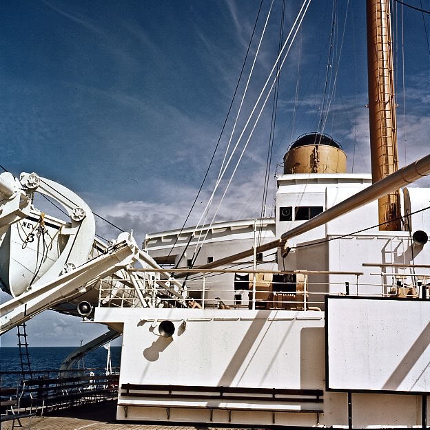
A little research shows that the Nevasa was built in 1956 as a troopship to government specifications and despite being operated by the British India Steam Navigation line, she sported a buff coloured funnel rather than the normal B.I. black funnel with two white bands.
The Nevasa had a tonnage of 20,527 tons with accommodation for 220 1st class pax, 110 2nd class, 180 3rd class and 1,000 troops on the troop decks.
My journey to the Far East in October 1956 was only the Nevasa’s second voyage; her maiden voyage had been to Malta. Nevasa served as a troopship from 1956 to 1962, but as National Service came to an end in the early 1960s and air transport became more efficient, troopships were made redundant, the last troopship voyage being made in December 1962 by the SS Oxfordshire to Malta. OK the Uganda and QE II were used in the Falklands campaign, but they weren’t designed as troopships.
In 1956 I was with Fighter Command Communications Squadron based at
Having been kitted out with tropical kit and received our overseas jabs we hung around Innsworth for about two weeks, but with no departure date set for the voyage we were sent home on leave for about six weeks, being told that once a firm departure date had been decided we’d receive a letter or telegram advising us when we had to return to Innsworth.
Six weeks of absolutely nothing to do on paid leave at home was quite splendid, I saw my girlfriend again — we’d already said our tearful farewells and here I was back again! So we went dancing and had a week by the sea at Clacton. Whilst at Clacton I was amazed at the constant procession along the main roads of convoys of army vehicles towing guns, all with newly applied sand-coloured desert camouflage as they proceeded to east coast ports for loading on vessels to be transported to the Middle East.
Rather enjoying life I spent a further few weeks saying further prolonged farewells to all my family and friends and had a rather good time at the taxpayer’s expense! The call-forward letter eventually arrived and I returned to Innsworth. The RAF draft for the Far East was bussed down to Southampton where we embarked on the ‘Nevasa’ — we sailed on the 16th of October 1956.
Five years earlier in 1951, as a newly conscripted RAF recruit, I was posted to R.A.F. Thornhill at the then Southern Rhodesia for service with No. 5 Flying Training School (5 FTS), the journey in those days being by sea as Cabin Class passengers on Union Castle Line liners from Southampton to Cape Town. Having already travelled by sea, albeit on an ocean liner (the RMS “Edinburgh Castle”) as a Cabin Class passenger, I had vague hopes that the Nevasa, reputably a modern troopship, would provide similar standards of comfort; sadly for us lower ranks the opposite was true, the voyage turned out to be one of the most uncomfortable and boring journeys I’ve ever made. Joining the Nevasa at Southampton the rumour was that because of the closure of the Suez Canal the Nevasa would be carrying up to twice the normal number of service personnel, in retrospect probably an exaggeration, but we were certainly carrying far more than the designed complement of troops. It was obvious when we embarked that the journey was not going to be anything like my fondly remembered comfortable passenger liner voyage. The bunks in the troop decks, normally three tiers high, had been rearranged by squeezing in an additional tier making four in all which meant that the space was so cramped that if one wanted to turn round in the bunk it could only be done by climbing out of the bunk and getting back in again. (The picture above of the bunks was taken two years later and shows standard 3-tier layout. On the way out in 1956 an extra tier had been added.)
On our troop deck near the bow, the toilets were designed for about half the number of men being carried and a queue regularly formed to use them. Both showers and wash basins were fed by salt water and the so called “salt-water” soap that we were given was a joke; there was just no way one could raise a lather with it to make oneself clean. There was one water fountain fed by fresh water which we used to clean our teeth.
During the voyage we ran into two quite severe storms, the first as
we left Southampton lasted for about three days as we passed through
the Bay of Biscay; the second was off the west coast of Africa in
the South Atlantic. For most troops on board the first storm was a
major upset, and nearly all were violently seasick. The packed bunks
meant those on the bottom tiers were regularly regurgitated on by
those above which was most unpleasant, one poor soul never really
gained his sea-legs and was sick for most of the one-month long
voyage. My memory of the food on board is that it was reasonable but
not anything to really write home about; with so many to cater for
the meals had to be taken in three separate half-hour
Apart from the occasional film, entertainment was virtually non-existent, when we reached the tropics films were shown on the open foredeck but with no seats we sat crossed-legged on the wooden deck and made our self as comfortable as possible. Being in the open the occasional tropical shower would terminate the performance, a memorable experience for all the wrong reasons!
The outdoor deck screen
We were invited to visit the bridge and couldn’t resist taunting the helmsman with 'The Navy Lark' catch phrase "Left hand down a bit!"
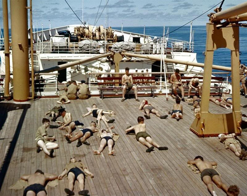
During the day we were required to do physical exercise on deck, with the army drill instructor shouting at us if we weren’t up to his ideal of physical perfection. Deck games were organised with team competitions between the various services and we also were taken to the rear of the ship and given a .303 rifle and invited to shoot at balloons that had been thrown into the water for target practice.
With the Suez Canal closed the long round the Cape route to the Far East meant stops in unfamiliar ports. We had a very short stop at Las Palmas in the Canary Islands to take on food and provisions; we were allowed to stretch our legs on the quayside but were forbidden from going into town. The next stop was Dakar in Senegal, at the time a French colony, civilised and a nice place to unwind, although we were only allowed ashore during the day.
Dakar allowed me to stock up with some Ektachrome colour 120 film for my reflex camera, which in 1956 was virtually unobtainable in the UK without a special licence.
Having left Dakar our next stop was Durban in South Africa. Between
Dakar and Durban the ship’s supply of beer ran out, which was pretty
disastrous. Sailing down the west coast of Africa towards the Cape,
we ran
At Durban, we were allowed ashore for the day and evening, with
orders to be back on board by midnight. I spent the day sightseeing,
swam and tried surfing in the Indian Ocean and in the evening
visited the Durban branch of the Royal Air Force Association which
was situated in a posh
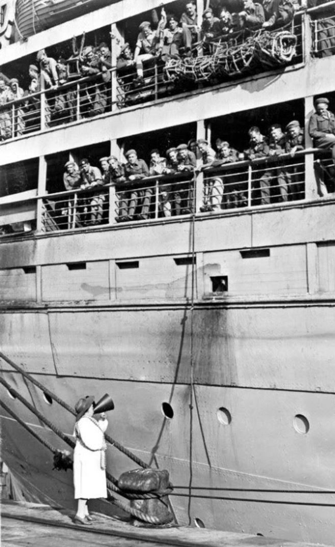
We departed Durban early the next morning and as we passed slowly out of the harbour towards the sea we were greeted by Mrs. Perla Gibson the ‘lady in white’, standing at the end of the northern breakwater and singing through her megaphone and waving to us, we could still see her waving, long after the sound of her voice had faded. The ‘lady in white’ was a wartime legend who sang to the troops as they left harbour on their journey to the battlefields of the Middle and Far East. When we arrived in Durban in 1956, the war had been over for 11 years, but still this lady knew we were coming and sang to us farewell greetings to speed us on our way.
Durban’s Lady in White is perhaps one of South Africa's most well known figures of the Second World War. The Lady in White, Mrs Perla Siedle Gibson became a well known figure to Allied troops at Durban harbour, which was South Africa’s busiest port during the war. Mrs Gibson was the daughter of a wealthy South African ship owner and studied as a young woman in Germany to be a soprano. She went on to give recitals in London and Manhattan.
Once described by Perla as her “wharfside work”, it began one day as she was seeing off a young Irish seaman who had been entertained by her family the day before. As his ship was departing, he shouted at her across the water, “Please sing something Irish.” She cupped her hands and started reciting the song, ‘When Irish Eyes are Smiling’. Throughout the years which followed she went on to sing to more than five thousand ships carrying an estimated quarter of a million Allied servicemen in total.
Perla Siedle would often stand at the harbour dressed in her trademark white dress and hat singing to the passing ships with the aid of a megaphone which came from a torpedoed liner as a gift from grateful English troops. Americans would often request that she sing such songs as ‘God Bless America’ and ‘The Star-Spangled Banner’.
English troops often asked for ‘There’ll Always Be an England’, while Australians preferred her performances of ‘Waltzing Matilda’, and South Africans always requested their own national folk songs like ‘Sarie Marais’. Czechs, Poles and Greeks chose opera arias.
Soldier’s talk eventually led to The Lady in White’s fame spreading across the world and ship captains would salute her as they were passing her. Perla Siedle was even known to U.S. soldiers as Kate Smith or Ma, to Britons as the Lady in White or the Soldiers’ Sweetheart, and to the Poles as the South African Nightingale. Perla Siedle was married to Air Sergeant Jack Gibson, last stationed at Foggia, Italy and also had two sons and one daughter in the South African Army. She had sung goodbye to all of them, watching their ships move out of sight over the bar to the tune of her favourite closing number, ‘Auld Lang Syne’. Even after the loss of one of her own sons, she refused to stop singing to the troops.
Mrs Gibson died in 1971, a shortly before her 83rd birthday, and a stone cairn with a bronze plaque was erected on Durban’s North Pier in June 1972. The memorial was erected on the site where she would have stood, singing to “her boys”.
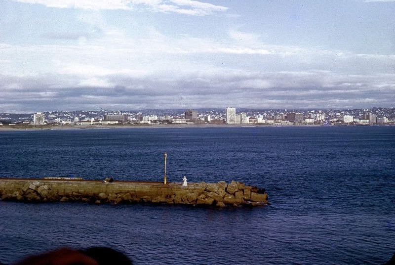
Leaving Durban, we headed northeast across the Indian Ocean towards the northern tip of Sumatra, passing the French island of Reunion on the way. Going around the northern trip of Sumatra we were astonished to see enormous numbers of sea snakes swimming in the sea. Eventually, about twelve-days later on 15th of November 1956 the Nevasa dropped anchor at Singapore. Pax for Singapore, Malaya and Ceylon disembarked and the Nevasa continued her voyage onwards to Hong Kong and Korea.
I spent a week at RAF Changi waiting for a flight to my FEAF posting at RAF Negombo in Ceylon.
|
||
|
IIf you lend someone $20 and never see that person again, it was probably well worth it
|
||
|
|
||
|
|
||
|
Back Go to page: 1 2 3 4 5 6 7 8 9 10 11 12 13 14 15 16 17 18 19 20 Forward |
||
|
|

 n
the white-painted 1000 feet markers barely 30 metres from the adjacent
road that parallels the runway.
n
the white-painted 1000 feet markers barely 30 metres from the adjacent
road that parallels the runway.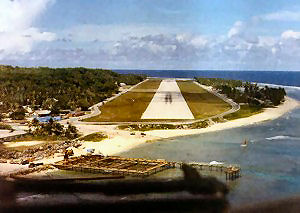
 miles and we diverted 50 miles off track to get around them.
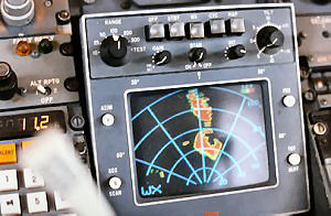 church were saved. Today, the parting of the lava flow on each side of
the church can still be seen.
church were saved. Today, the parting of the lava flow on each side of
the church can still be seen.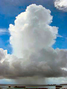 a wide lagoon and the ocean. The Minimum Descent Altitude (MDA) for the
NDB approach is quite low at 370 feet – reflecting lack of significant
obstacles; that is if you don’t count the masts of freighters or yachts
at anchor in the lagoon.
a wide lagoon and the ocean. The Minimum Descent Altitude (MDA) for the
NDB approach is quite low at 370 feet – reflecting lack of significant
obstacles; that is if you don’t count the masts of freighters or yachts
at anchor in the lagoon.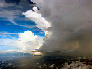 shuffled to calculate a PNR on Nadi at our seven o’clock position at 600
miles and falling behind us at six miles a minute.
shuffled to calculate a PNR on Nadi at our seven o’clock position at 600
miles and falling behind us at six miles a minute.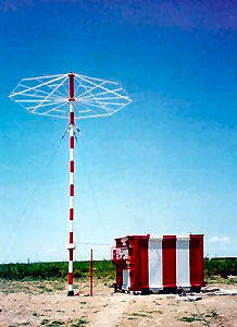 used by DH Herons of Air Tungaru, the national airline of the Gilbert
Islands. These navaids seldom worked because of shortage of fuel shipped
in by sea to run the diesel generators.
used by DH Herons of Air Tungaru, the national airline of the Gilbert
Islands. These navaids seldom worked because of shortage of fuel shipped
in by sea to run the diesel generators.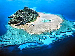 t
crosscheck confirmed we were still on track for Nauru.
t
crosscheck confirmed we were still on track for Nauru.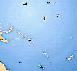 knots. With a short runway wet from rain and absence of safe over-runs,
Nauru was no place to land fast and risk skidding off the end.
knots. With a short runway wet from rain and absence of safe over-runs,
Nauru was no place to land fast and risk skidding off the end.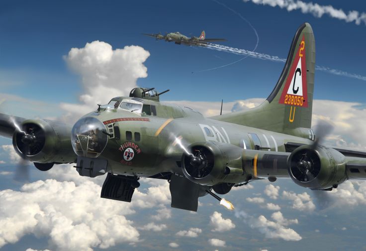 ever wondered who Roger Wilco is? And why pilots like to say his name?
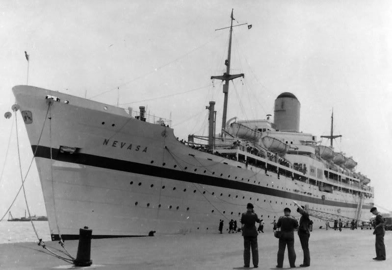
 RAF Bovingdon near Hemel Hempstead in Hertfordshire. In July 1956 I
received the standard PWR (Preliminary Warning Role) letter
notifying me that I had been selected for posting to the Far East
Air Force (FEAF) and that I was to report to number 5PDU at RAF
Innsworth in Gloucestershire to be kitted out for my posting.
Departure date from Southampton was scheduled for 19th of August
1956 on the SS Nevasa. In the event, with the Suez crisis in full
swing and the closure of the Suez Canal the planned sailing date was
postponed to an undecided future date. With the Canal closed we were
told that we would be travelling on the ‘long’ route around the Cape
of Good Hope and we were to remain at RAF Innsworth pending a new
departure date.
RAF Bovingdon near Hemel Hempstead in Hertfordshire. In July 1956 I
received the standard PWR (Preliminary Warning Role) letter
notifying me that I had been selected for posting to the Far East
Air Force (FEAF) and that I was to report to number 5PDU at RAF
Innsworth in Gloucestershire to be kitted out for my posting.
Departure date from Southampton was scheduled for 19th of August
1956 on the SS Nevasa. In the event, with the Suez crisis in full
swing and the closure of the Suez Canal the planned sailing date was
postponed to an undecided future date. With the Canal closed we were
told that we would be travelling on the ‘long’ route around the Cape
of Good Hope and we were to remain at RAF Innsworth pending a new
departure date.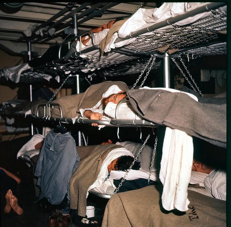
 sittings.
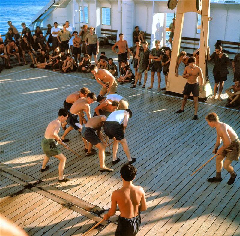
 into a severe South Atlantic storm, so much is so that the boat’s
hull was regularly lifted out of the water and came down with an
enormous great crash which reverberated throughout the ship, being
in the bow we experienced it the most, this weather lasted for about
three days. Having rounded the Cape and heading north along the east
coast of South Africa towards Durban the weather abated, and we
enjoyed a quieter couple of days.
into a severe South Atlantic storm, so much is so that the boat’s
hull was regularly lifted out of the water and came down with an
enormous great crash which reverberated throughout the ship, being
in the bow we experienced it the most, this weather lasted for about
three days. Having rounded the Cape and heading north along the east
coast of South Africa towards Durban the weather abated, and we
enjoyed a quieter couple of days.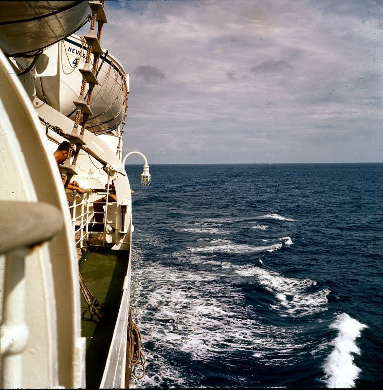 area of town. The RAFA locals were so generous I don’t think any of
the RAF servicemen who went for a drink at their club that evening
had to pay for anything.
area of town. The RAFA locals were so generous I don’t think any of
the RAF servicemen who went for a drink at their club that evening
had to pay for anything.